- Wêreld
- »
- US
- »
- Texas
- »
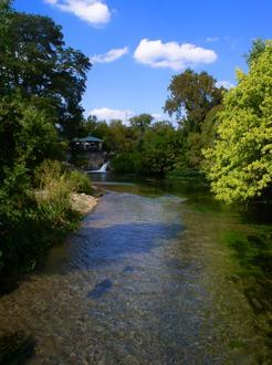
- Staples, Texas
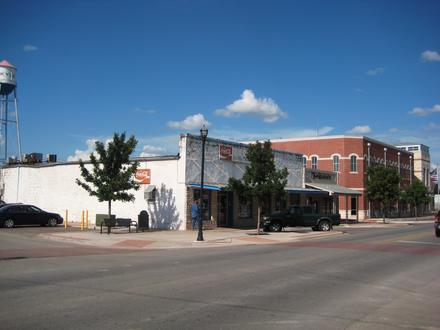
Besighede in Staples
| Oppervlak van Staples, Texas | 1,501 myl² |
| Bevolking | 318 |
| Bevolkingsverandering vanaf 1975 tot 2015 | +158,5% |
| Bevolkingsverandering vanaf 2000 tot 2015 | +76,7% |
| Area Kodes | 512 |
| Lokaaltyd | Saterdag 21:52 |
| Tydsone | Noord-Amerikaanse sentrale dagligtyd |
| Lengte & Breedtegraad | 29.78133° / -97.83611° |
| Poskodes | 78670 |
Kaart - Staples, Texas
Bevolking Staples, Texas
Jaar 1975 tot 2015| data | 1975 | 1990 | 2000 | 2015 |
|---|---|---|---|---|
| Bevolking | 123 | 161 | 180 | 318 |
| Bevolkingsdigtheid | 82.0 / mi² | 107.3 / mi² | 119.9 / mi² | 211.9 / mi² |
Bevolkingswisseling vanaf 2000 tot 2015 Staples
Verhoging van76,7% vanaf jaar2000 tot 2015| Plek | Verandering sedert 1975 | Verandering sedert 1990 | Verandering sedert 2000 |
|---|---|---|---|
| Staples, Texas | +158,5% | +97,5% | +76,7% |
| Texas | +111% | +60,8% | +31,3% |
| Verenigde State van Amerika | +46,9% | +27,2% | +13,7% |
Bevolkingsdigtheid Staples, Texas
Bevolkingsdigtheid: 211.9 / mi²| Plek | Bevolking | gebied | Bevolkingsdigtheid |
|---|---|---|---|
| Staples, Texas | 318 | 1,501 myl² | 211.9 / mi² |
| Texas | 27.5 miljoen | 268 597,7 myl² | 102.5 / mi² |
| Verenigde State van Amerika | 321.6 miljoen | 3 796 761,2 myl² | 84.7 / mi² |
Geskiedkundige en Geprojekteerde Bevolking Staples, Texas
Geskatte bevolking vanaf 1860 tot 2100Sources:
1. JRC (European Commission's Joint Research Centre) work on the GHS built-up grid
2. CIESIN (Center for International Earth Science Information Network)
3. [skakel] Klein Goldewijk, K., Beusen, A., Doelman, J., and Stehfest, E.: Anthropogenic land use estimates for the Holocene – HYDE 3.2, Earth Syst. Sci. Data, 9, 927–953, https://doi.org/10.5194/essd-9-927-2017, 2017.
Menslike Ontwikkelingsindeks (HDI)
Statistiese saamgestelde indeks van lewensverwagting, opvoeding en per capita-inkomste.Sources: [Link] Kummu, M., Taka, M. & Guillaume, J. Gridded global datasets for Gross Domestic Product and Human Development Index over 1990–2015. Sci Data 5, 180004 (2018) doi:10.1038/sdata.2018.4
CO2-emissies Staples, Texas
Koolstofdioksied (CO2) -uitlatings per capita per ton per jaar| Plek | CO2-emissies | CO2-emissies per capita | CO2-emissiesintensiteit |
|---|---|---|---|
| Staples, Texas | 5 670 VSA-t. | 17,8 VSA-t. | 3 778 VSA-ton/mi² |
| Texas | 488 896 034 VSA-t. | 17,8 VSA-t. | 1 820 VSA-ton/mi² |
| Verenigde State van Amerika | 5 664 619 809 VSA-t. | 17,6 VSA-t. | 1 491 VSA-ton/mi² |
CO2-emissies Staples, Texas
| CO2-emissies (metrieke ton/jaar) 2013 | 5 670 VSA-t. |
| 2013 CO2-emissies (metrieke ton/jaar) per capita | 17,8 VSA-t. |
| CO2-emissie-intensiteit 2013 |
Natuurlike gevare risiko
Relatiewe risiko uit 10| droogte | Medium (5) |
| vloed | Hoog (10) |
* Risiko's, veral met betrekking tot oorstromings of grondverskuiwings, is moontlik nie vir die hele gebied nie.
Sources: 1. Dilley, M., R.S. Chen, U. Deichmann, A.L. Lerner-Lam, M. Arnold, J. Agwe, P. Buys, O. Kjekstad, B. Lyon, and G. Yetman. 2005. Natural Disaster Hotspots: A Global Risk Analysis. Washington, D.C.: World Bank. https://doi.org/10.1596/0-8213-5930-4.
2. Center for Hazards and Risk Research - CHRR - Columbia University, Center for International Earth Science Information Network - CIESIN - Columbia University, and International Research Institute for Climate and Society - IRI - Columbia University. 2005. Global Drought Hazard Frequency and Distribution. Palisades, NY: NASA Socioeconomic Data and Applications Center (SEDAC). https://doi.org/10.7927/H4VX0DFT.
3. Center for Hazards and Risk Research - CHRR - Columbia University, Center for International Earth Science Information Network - CIESIN - Columbia University. 2005. Global Flood Hazard Frequency and Distribution. Palisades, NY: NASA Socioeconomic Data and Applications Center (SEDAC). https://doi.org/10.7927/H4668B3D.
Onlangse aardbewings in die omgewing
Grootte 3.0 en groter| Datum | Tyd | grootte | Afstand | diepte | Plek | skakel |
|---|---|---|---|---|---|---|
| 2019-06-15 | 18:07 | 3,6 | 87,8 km | 5 000 m | 9km SE of Poth, Texas | usgs.gov |
| 2019-05-14 | 03:52 | 3,1 | 58 km | 5 000 m | 10km E of Nixon, Texas | usgs.gov |
| 2019-05-12 | 07:37 | 3,1 | 77,1 km | 5 000 m | 19km WNW of Cuero, Texas | usgs.gov |
| 2018-12-21 | 21:32 | 3,2 | 80,4 km | 5 000 m | 18km E of Poth, Texas | usgs.gov |
| 2018-05-01 | 09:28 | 4 | 93,8 km | 5 000 m | 12km NW of Karnes City, Texas | usgs.gov |
| 2018-04-26 | 11:49 | 3,1 | 98 km | 5 000 m | 15km WNW of Karnes City, Texas | usgs.gov |
| 2018-02-12 | 06:24 | 3,1 | 86,1 km | 5 000 m | 13km N of Karnes City, Texas | usgs.gov |
| 2015-02-19 | 12:31 | 3,1 | 93,2 km | 5 000 m | 3km N of Hallettsville, Texas | usgs.gov |
| 2008-04-07 | 02:51 | 3,9 | 97,5 km | 5 000 m | southern Texas | usgs.gov |
| 1991-07-20 | 16:38 | 3,6 | 98,8 km | 10 000 m | southern Texas | usgs.gov |
Vind historiese aardbewings wat voorgekom het naby Staples, Texas
Vroegste datum Laaste datum
Grootte 3.0 en groter Grootte 4.0 en groter Grootte 5.0 en groter
Oor ons data
Die gegewens op hierdie bladsy word geskat met behulp van 'n aantal gereedskap en bronne wat in die openbaar beskikbaar is. Dit word voorsien sonder waarborg, en dit kan onakkuraathede bevat. Gebruik dit op eie risiko. Kyk hier vir meer inligting.