Kategorieë in Nan
Industries
Besigheidsverspreiding volgens bedryf in Nan
| Bedryfsbeskrywing | Aantal inrigtings | Gemiddelde ouderdom van besigheid |
|---|---|---|
| Restaurante | 1,419 | — |
| Inkopies | 632 | 23 year |
| Ander akkomodasie | 607 | 13 year |
| Kafees | 466 | — |
| Publieke administrasie | 353 | — |
| Opvoeding | 334 | — |
| Godsdiens | 293 | — |
| Kruidenierswinkels en supermarkte | 265 | — |
| Hotelle en motelle | 253 | — |
| Motorwerktuigkundige | 186 | — |
| Korporatiewe bestuur | 156 | — |
Nan feite
| gebied | 111.3 km² |
| Bevolking | 84 092 |
| Manlike bevolking | 41 949 (49.9%) |
| Vroulike bevolking | 42 143 (50.1%) |
| Bevolkingsverandering (1975 to 2020) | +18.8% |
| Bevolkingsverandering (2000 to 2020) | -7.0% |
| Gemiddelde ouderdom | 38.4 jaar (Manlik: 37.3, Vroulik: 39.4) |
| Area Kodes | 54 |
| Woongebiede | Tambon Nai Wiang, Tambon Pha Sing, Tambon Du Tai, Tambon Pua, อำเภอเมืองน่าน(ในเวียง) |
| Lokaaltyd | |
| Tydsone | Indosjina-tyd |
| Lengte & Breedtegraad | 18.78378, 100.77899 |
| Poskodes | 55000 |
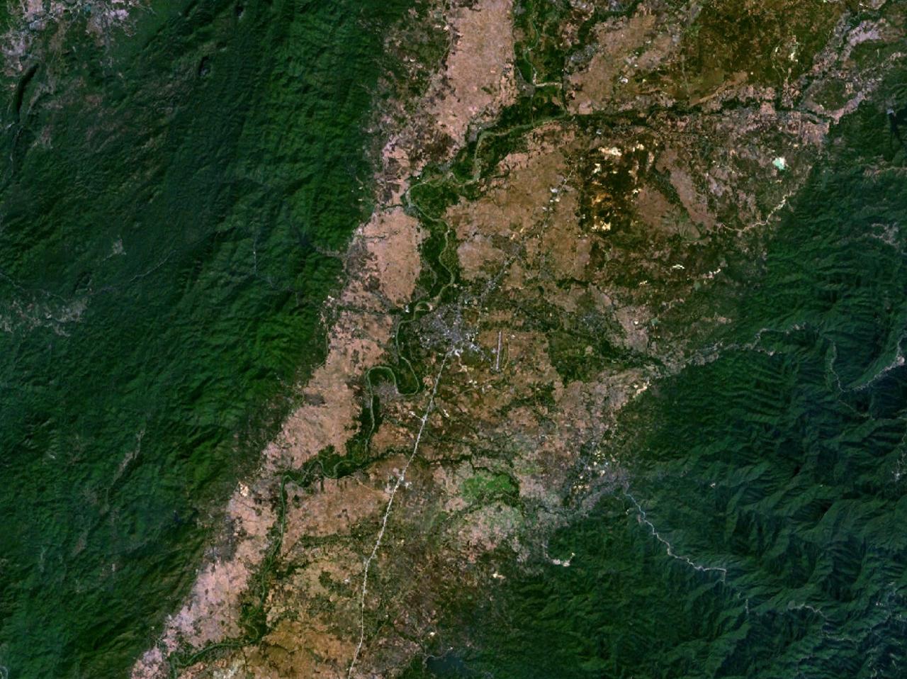
Kaart van Nan
Interaktiewe kaart
Nan bevolking
Jaar 1975 tot 2020
| Data | 1975 | 1990 | 2000 | 2015 | 2020 |
|---|---|---|---|---|---|
| Bevolking | 70 789 | 90 214 | 90 380 | 81 711 | 84 092 |
| Bevolkingsdigtheid | 635,9 / km² | 810,5 / km² | 811,9 / km² | 734,1 / km² | 755,5 / km² |
Nan bevolkingsverandering van 2000 tot 2015
Afname van 9.6% van jaar 2000 tot 2015
| Plek | Verandering sedert 1975 | Verandering sedert 1990 | Verandering sedert 2000 |
|---|---|---|---|
| Nan | +15.4% | -9.4% | -9.6% |
| Changwat Nan | +23.1% | -4.2% | -7% |
| Thailand | +60.4% | +20.1% | +8.3% |
Nan mediaan ouderdom
Mediaan ouderdom: 38.4 jaar
| Plek | Gemiddelde ouderdom | Mediaan ouderdom (vroulik) | Mediaan ouderdom (manlik) |
|---|---|---|---|
| Nan | 38.4 yrs | 39.4 yrs | 37.3 yrs |
| Changwat Nan | 38.3 yrs | 39.4 yrs | 37.2 yrs |
| Thailand | 35.2 yrs | 36 yrs | 34.3 yrs |
Nan bevolkingsdigtheid
Bevolkingsdigtheid: 756 / km²
| Plek | Bevolking | gebied | Digtheid |
|---|---|---|---|
| Nan | 84 092 | 111,3 km² | 756 / km² |
| Changwat Nan | 448 336 | 11 721,9 km² | 38,2 / km² |
| Thailand | 67,6 million | 514 961,7 km² | 131 / km² |
Nan historiese en geskatte bevolking
Geskatte bevolking van 1810 tot 2100
- JRC (European Commission's Joint Research Centre) werk aan die GHS built-up grid
- CIESIN (Center for International Earth Science Information Network)
- [skakel] Klein Goldewijk, K., Beusen, A., Doelman, J., and Stehfest, E.: Anthropogenic land use estimates for the Holocene – HYDE 3.2, Earth Syst. Sci. Data, 9, 927–953, https://doi.org/10.5194/essd-9-927-2017, 2017.
Buurte in Nan
Persentasie besighede volgens buurt in Nan
Area Kodes
Persentasie Areakodes wat deur besighede gebruik word in Nan
Poskodes
Persentasie besighede volgens poskodes in Nan
Prysverspreiding
Besigheidsverspreiding per prys vir Nan
Menslike Ontwikkelingsindeks (HDI)
Statistiese saamgestelde indeks van lewensverwagting, opvoeding en per capita-inkomste.
Nan CO2-uitlatings
Koolstofdioksied (CO2) -uitlatings per capita per ton per jaar
| Plek | CO2-emissies | CO2-emissies per capita | CO2-emissiesintensiteit |
|---|---|---|---|
| Nan | 335,415 tn | 3.99 tn | 3,013.3 tons/km² |
| Changwat Nan | 1,708,622 tn | 3.81 tn | 145.8 tons/km² |
| Thailand | 278,589,420 tn | 4.12 tn | 541 tons/km² |
| 2013 CO2-uitlatings (tonne/jaar) | 335,415 tn |
| 2013 CO2-uitlatings (tonne/jaar) per capita | 3.99 tn |
| 2013 CO2-uitlatings-intensiteit (tonne/km²/jaar) | 3,013.3 tons/km² |
Natuurlike gevare risiko
Relative risk out of 10
| Gevaar | Risk Level |
|---|---|
| Drought | High (9) |
| Flood | Medium (4) |
| Earthquake | Medium (3.6) |
| Cyclone | Medium (5) |
* Risk, particularly concerning flood or landslide, may not be for the entire area.
- Dilley, M., R.S. Chen, U. Deichmann, A.L. Lerner-Lam, M. Arnold, J. Agwe, P. Buys, O. Kjekstad, B. Lyon, and G. Yetman. 2005. Natural Disaster Hotspots: A Global Risk Analysis. Washington, D.C.: World Bank. https://doi.org/10.1596/0-8213-5930-4.
- Center for Hazards and Risk Research - CHRR - Columbia University, Center for International Earth Science Information Network - CIESIN - Columbia University, International Bank for Reconstruction and Development - The World Bank, and United Nations Environment Programme Global Resource Information Database Geneva - UNEP/GRID-Geneva. 2005. Global Cyclone Hazard Frequency and Distribution. Palisades, NY: NASA Socioeconomic Data and Applications Center (SEDAC). https://doi.org/10.7927/H4CZ353K.
- Center for Hazards and Risk Research - CHRR - Columbia University, Center for International Earth Science Information Network - CIESIN - Columbia University, and International Research Institute for Climate and Society - IRI - Columbia University. 2005. Global Drought Hazard Frequency and Distribution. Palisades, NY: NASA Socioeconomic Data and Applications Center (SEDAC). https://doi.org/10.7927/H4VX0DFT.
- Center for Hazards and Risk Research - CHRR - Columbia University, Center for International Earth Science Information Network - CIESIN - Columbia University. 2005. Global Flood Hazard Frequency and Distribution. Palisades, NY: NASA Socioeconomic Data and Applications Center (SEDAC). https://doi.org/10.7927/H4668B3D.
- Center for Hazards and Risk Research - CHRR - Columbia University, Center for International Earth Science Information Network - CIESIN - Columbia University. 2005. Global Earthquake Hazard Distribution - Peak Ground Acceleration. Palisades, NY: NASA Socioeconomic Data and Applications Center (SEDAC). https://doi.org/10.7927/H4BZ63ZS.
Onlangse aardbewings in die omgewing
Grootte 3.0 en groter

Oor ons data
Die data op hierdie bladsy word geskat met behulp van 'n aantal publiek beskikbare gereedskap en hulpbronne. Dit word verskaf sonder waarborg en kan onakkuraathede bevat. Gebruik op eie risiko.